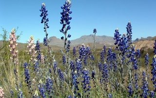

Driving south out of Alpine, Marathon, Marfa, you can’t help but notice geology.
 Even the name Big Bend is a geologic description; the great southern curve that the Rio Grande has carved over countless millennia. Visitors (and we’re all just visiting) wonder “how’d it get this way”. Its not easy to imagine the immensity of time involved, but we can try to understand the forces, and the sequence of events that led to the current appearance of the Big Bend landscape. Most of these forces are gradual, unnoticed during a human life span. The geologic record also indicates signs of rapid cataclysmic change: volcanic eruptions, floods, tidal waves, etc.
Big Bend is shaped by a variety of planetary processes. The oldest exposed rocks in the area were formed by ocean sediments 500 millions years ago. Crustaceans lived and died in warm, relatively shallow ocean waters. The steady rain of shell fragments over millions of years slowly sunk into the spreading ocean floor, and were converted by great pressures into dense limestones.
250 million years ago, give or take a few millennia, the South American tectonic plate crashed into the North American plate. The smoothly bedded horizontal limestones under the Paleozoic sea were placed under immense stress in the collision: uplifted, twisted, metamorphosed. These events formed the Appalachian and Ouachita mountains of the eastern US. Rocks from this period are exposed in the Marathon Basin in an easily identifiably formation know as los Caballos (the horses). Look for them driving south on US 385 from Marathon towards Big Bend National Park. Traces of this ancient formation are also exposed in the remote Solitario in Big Bend Ranch State Park, and in an obscure road cut on US 118, about 40 miles south of Alpine.
Conveniently for our brief overview, rocks formed during the ensuing 150 million years are not present in Big Bend. Possibly, a period of tectonic inactivity was accompanied by years of erosion and valley fill. Many years. Whatever late Paleozoic/ Early Mesozoic mountains that existed were probably converted into gravel and deposited into the most convenient ocean.
During the Cretaceous period, from 140-70 million years ago, Big Bend was covered by a shallow inland sea that stretched from what is now the gulf of Mexico, all the way to Alaska. During this period, the area was intermittently inundated with deep ocean, resulting in the massive limestones of the Boquillas, Glen Rose, Santa Elena and Del Carmen formations; and then interspersed with relatively shallow, tidal influenced waters and estuaries. Geological strata from certain periods contain fossils of large marine reptiles: mosasaurs, turtles, crocodiles, etc. Deposits from the late Cretaceous deposits, when seas were in recession, produce abundant dinosaur fossils, including Pterosaurians, Hadrosaurians and Ceratopsians.
This brings us almost up to modern time, only 65 million years ago. The pace speeds up. A large asteroid strikes the earth in what is now the bay of Campeche. The dinosaurs, along with many other plant and animal species, become extinct. The Pacific plate collides with North America. The shock of this forms mountains and valleys all over the continent, most notably the Rocky Mountain Range. In Big Bend a number of important events took place during this period. Hot magma from deep in the earth, under high pressure, worked its way into the cracks and fissures of the local sedimentary rock, and is now exposed as the horizontal red “sills” visible downstream of Lajitas. In some places : Sierra Quemada, Sierra Rica, Pine Canyon, molten magma found its way to the surface; volcanic eruptions of the most violent nature occurred. Cubic kilometers of incandescent magma raced from eruption sites, hugging the valleys. This glowing material slowed and settled to form the welded tuffs common in the Big Bend Ranch State Park and adjacent areas. Some magma was instantaneously atomized and blown higher into the atmosphere, cooling as individual particles, settling out as a volcanic ash, called tuff, which is apparent just north of Castolon in Big Bend National Park, and west of Lajitas on Highway 170, El Camino del Rio.
To further complicate matters, all the twisting, pushing and pulling going on not only lifted the massive limestones of Mesa de Anguila and the Sierra del Carmen, but also dropped a large slab of the same rock down almost 2000′ feet, in between the two. This “Sunken Block” , was later breached by volcanic activity, forming the Chisos Mountains. Add 35 million years of erosion later and here we are.
Since humans happened on the scene, Big Bend has been quiet, but not still . Erosional forces, including mankind, topple the mountains, and fill the valleys. Torrential rains carry valley fill down the arroyos, to the Rio Grande, and on to the Gulf of Mexico. The towering limestones are still being uplifted at 3 inches per century. The Rio Grande is taking away at least that much. In Big Bend, geological forces are a part of everyday life.